

The frustrating dog restrictions I’d encountered during my previous visit to Great Whernside had now being rendered, the technicalities and red-tape I’d needed to overcome had being exhausting and emotionally draining, leaving my canine companion behind was heart wrenching but, some sacrifices in life need to be faced head on if progress if ever going to be achieved, the NO DOGS rule still needs addressing, a footpath or bridleway is one or the other, and, to add restrictions just doesn’t equate. Oh the drama!
 So, once again, no more than a week after my previous visit, I was back, at Kettlewell, my newly discovered favourite dales village. Coming back to reality and the subject of my blog, I was retracing my previous destination with the destination being Great Whernside, and the beauty of this, my second attempt, was, from the same starting point to the same destination, I was venturing on a totally different route with only a partial retracing of my previous tracks. Instead of following the Dales Way alongside the River Wharfe to Starbotton, as I’d done previously, this was a shorter, more direct route from Kettlewell to Tor Dyke and taking the tracks from there to the summit, it didn’t involve an overnight wild camp and it wouldn’t involve any restrictions.

That back pack was my small 25L one, it’s all I needed for the single day’s outing, kit minimalisation is something I swear by, not everybody agrees with me, but, I subscribe to taking the bare essentials and nothing more, keeping the weight off your back makes life a great deal easier, I used to be part of the “what if” and “just in case” brigade but that was a long time ago, there is simply no point in carrying excessive amounts of equipment that you’ll never use. The only “extras” I carry are batteries, those for my GPS and mini torch.
The route from the centre of the village was almost directly north, the whole north and nothing but the north, so help me Odin, following the minor road out for only a few yards prior to a left turn onto Top Mere Road, it’s a track and not a road, but, a great route all the same.

As I made my ascent on this wonderful track I had my first encounter with a herd of cows, recent reports of these potential beasts had given me a great cause for concern, look at them here, I’d only just stopped to have direct eye contact with them and they’d ganged up on me, I could read their eyes, they weren’t happy, they wanted to give me a real kicking, hmm, no chance, from the safety of my side of the dry stone wall I was free to ridicule them, give them threats of “Sunday Dinner” and “Yorkshire Puddings”, what could they do about it, I cursed them with a final warning of “horseradish sauce” and left them to worry about it. On this occasion, I called the shots.
It was about 3.5K to the junction with Starbotton Road, and, it didn’t take me long before I’d discovered the isolation I’d come in search of, a couple of walkers past me by, their leggings and boots reflecting the wet conditions they’d encountered earlier on their journey, a testimony for me of what to expect. It’s magnificent how, this new route offered such a different scenery, only a few hundred yards from my previous starting point yet I could have been a hundred miles from it, such is the beauty of these deep valleys. The walking wasn’t difficult, and, if it was a road, it certainly wasn’t meant for today’s regular motor vehicles. A farmer passed me in his well beaten Land Rover as he headed upwardly to gather his sheep, and a quad passed me heading down, back into the village, both gave the track the respect it deserved, they drove slowly over the bumpy terrain, they knew better than not to.

It was a warm and humid day, it was marvellous to be only wearing a t-shirt, and, because of the heat and the initial exertion that’s always required at the start of any walk, the water needed to replace the fluid the body loses is very noticeable, I think within the first hour I’d drank most of the water I’d been carrying, fortunately, replacement from surrounding streams and springs is plentiful. At the spring pictured I topped up my bottle, the wonderful fresh water, the wonderful brown, peat stained water, the wonderful brown, peat stained fresh water that may have recently flowed through a dead sheep, oh, the delights of being thirsty. I topped up from the fastest flowing part of the spring and added a sterry tab, and, as instructed, left it at least 30 minutes to purify, well, I left it a lot longer as I was refreshed. It was reassuring to have replenished my water supply.
The entire ascent wasn’t too difficult with new and wonderful views in every surrounding direction, for all the negative press reflected on parts of some of the Yorkshire cities, the dales certainly compensate with an immense wealth of beauty that’s almost difficult to put into words.
On completing Top Mere Road, I approached a location I’d now become familiar with, the junction of Starbotton Road (another track). Whilst nearly there I’d passed two ladies who were retuning to Kettlewell, we shared greetings and it was clear to me they were from Lancashire, their accents were quite broad, then, as I was almost on the adjoining track, a group of about 6 or 7 walkers were following the road towards Starbotton, I’d never seen so many people up there before.

Once on the familiar track leading to my destination, the historic feeling of the past surrounded me, this was the location where defining events in British history occurred, the manpower to construct such a defence, a defence in defiance of an aggressive, oppressive, imperialistic army of occupation, who’s soldier’s were immune from crimes against the civilian population, The Dyke speaks volumes regarding their threat, such a defensive construction of this size wouldn’t have being manufactured had there being no peril. If only this place could talk and reveal its secrets, how many bones lay scattered beneath?

From almost nowhere appeared another two walkers, twin sisters, it was lovely to chat with them for a couple of minutes, they were heading to Starbotton and a return trip to Kettlewell via the Dales Way footpath, they were basically doing my original route in reverse, I told them about the bridge at Starbotton being difficult to find, they thanked me for the little piece of advice and, clutching to their full sized map, departed.
The pleasure of crossing the dyke was again, immeasurable, I really have discovered another wonder of the dales and within half an hour I’d reached the point of termination on my previous journey, the gate with the NO DOGS sign attached to it. Coffee and break time, no Meg with me so there was no reason not to continue. I boiled some of my water and made a well earned coffee, parked myself down and tucked into some snack, being located on the west side of the wall, alongside the gate, I was invisible to anybody descending from the GW summit. I suddenly heard a male voice descending from the summit, I couldn’t see anybody nor could they see me, as they closed in towards the wall and it’s stile, I could hear the voice discussing the dyke and how he considered it a man made defensive structure. He suddenly appeared as he climbed over the walls stile, the shock on his face as he saw me sat there was a delight, it was hilarious seeing his surprised expression, he was on his own and obviously having a great debate with himself, he didn’t expect another forlorn walker to be sitting there, listening with great interest to his hearty conversation, (shame he was complaining about his wife or work, that would have being far more entertaining), but, fair play to him, he simply continued his debate and aimed it at me, we chatted about the dyke for a couple of minutes, neither knowing too much about it’s true history, but, it was still good fun, then, as fast as he’d arrived, he was gone.

Finally, my time to ascend Great Whernside had arrived, the ascending footpath was clearly visible, the route takes the intrepid walker over a hillside known as Black Dyke, and the terrain underfoot completely changes. Instead of the easier walking with a solid ground beneath, this was becoming very wet and marshy, the ascent became steep and far more challenging.
As for the endangered local wildlife, those being the reason for dogs not permitted on the fell, well, I didn’t see any, let alone upset them. Nor do I subscribe to the macho ‘no pain, no gain’ society, I’m more of a Paddington Bear than Bear Ghrylls, this was tough climbing. Ahead, whilst slogging up the long wet, marshy track, I saw what I initially thought may be a stone circle, I adore these mysterious constructions, but, there was no mention of it on the map and, it wasn’t until I reached it, did I realise it was nothing more than a few boulders laying loosely around another spring, never mind, I did wonder how many people over the last few thousand years had taken refreshment from it.

On reaching the wonderful summit I wasn’t too sure of my precise location, not that it mattered, not in the least, being there was more than sufficient, the sense of achievement that I always feel was present, there isn’t much to better such a feeling. Unlike most summits, GW doesn’t have a defined peak, the trig point was still a good few minutes walk from the location of arrival. Is this a long, erratic strewn plateau? The Norber erratics are one of the finest groups of glacial erratic boulders in Britain, they are classic geomorphological features from the glaciation of northern England. Many of the Millstone Grit boulders are perched on pedestals of limestone . The boulders were probably deposited by melting ice sheets at the end of the last ice age, around 12,000 years ago. The pedestals have developed because the erratic boulders have protected the underlying limestone from solution by rainfall, giving estimates of the rate of lowering of the surrounding limestone pavement of around 25mm per 1000 years. Recent cosmogenic dating suggests that the boulders have been exposed for around 17,900 years. This lovely collection, it would seem, aren’t erratics.
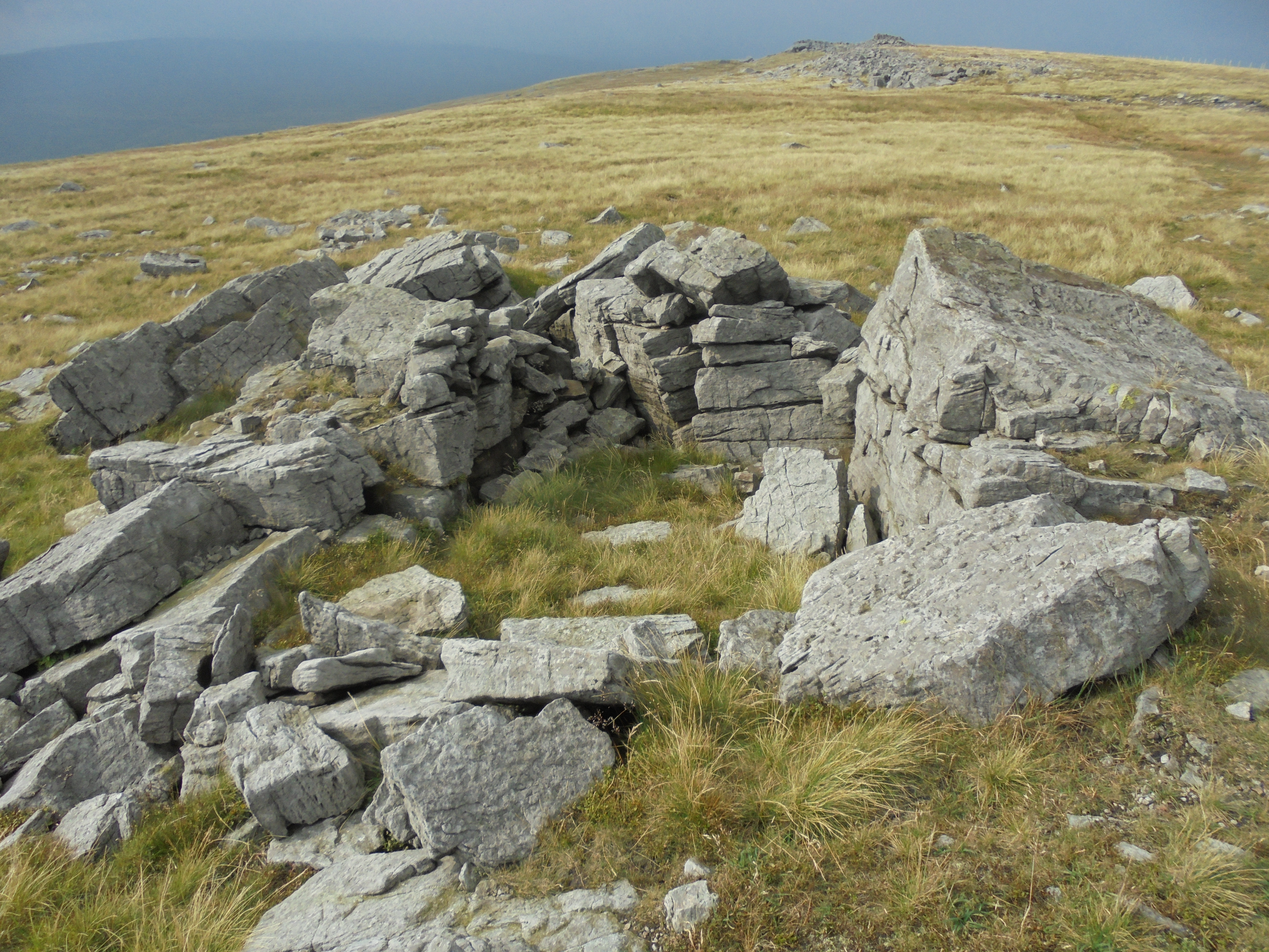
The plateau was quite windy, but not enough to require another layer of clothing, the twin sisters I’d briefly chatted to earlier, said how my later ascent had being a good decision as the cloud and mist they’d encountered whilst they were there had now cleared and I’d have a much better view, they weren’t wrong, it was now very clear and sunny, I was lucky. It’s certainly not a featureless plateau, it’s scattered with what I believed to have being Norber Erratics, I’ve since being pointed out they weren’t, and man made shelters, the latter not being required that day, but, I have being in similar locations in winter when their need has being paramount.

Ten or fifteen minutes later, the trig point and I made our first acquaintance, it didn’t feel like such, more like I was meeting a long lost old friend, I’d being anticipating this moment with great excitement. This is where I took my second and longest break of the day, I moved down from the TP, only a few feet, just enough to shelter from the wind, I still didn’t require any more clothing, it was warm enough. This is where I really did open my backpack and delight in the few bits of snack and drinks I’d brought along. I made the decision to compare the grid reference point and the elevation level with my GPS, I had the printed figures on the map, how would the GPS compare, an interesting little challenge. The results were obscenely close, unbelievably accurate, how technology has improved in such a basically short period of time, impressive was an understatement.

Summit completed, coffee and snack consumed, boots removed for a close inspection of newly earned scratches, back pack repacked, the descent commenced. Again, the route is a clearly defined footpath heading south west between Whernside and Whernside pasture (neither having any connection to the Whernside of the 3 Yorkshire Peaks family), again, I was soon trudging through deep, wet boggy peat filled marsh, In winter this could be impassable and far too deep, Once, in the Lake District, I was winter walking, and, I leapt over some flooded marshy terrain only to sink, waste deep into it, at which point the camera in my jacket ended up floating in the water filled pocket, no photos from that excursion. Through this marshy terrain, the footpath becomes lost to the marsh and peat, there are little cairns around, plus yellow painted wooden guidance stakes, both proved to be of assistance.
Hag Dyke soon came into view, at some point it was probably a farm house but these days it’s owned by a Boy Scout group from Ilkley. The scramble down to it has a very severe challenge, loose shingle on a very severe 50 foot high vertical part of the trail, A little tester, a wonderful little unexpected tester.

Following the footpath down, it takes a very unusual route, it goes the hostel, literally through the garden and past the kitchen, I doubt if this was the case when it was a private farm on land without public access, but, thankfully, times have changed.
From Hag Dyke there’s a choice of two footpaths, one being a bridle way for vehicles whereas the other is purely a footpath which runs adjacent to Dowber Gill Beck. I chose the footpath, how I wished the hostel was my home and I could use the footpath on a daily basis, this isn’t God’s Own County, it’s Thor’s Own County, it’s Valhalla, it’s paradise. Why people choose to spend their precious vacation time frying on a boring beach in Benidorm defeats me, it’s not fun, it’s not enjoyable, being in locations like this, in any weather, really is, well, it is to me.

At the head of Dowber Gill Beck, stands, or rather sinks, Providence Pot, I know nothing at all about it, according to the map, there’s a lead mine alongside it with the same name, it was pointed out to me by an old childhood friend of mine I’ve recently rediscovered on Facebook, Chris Booth, another former Roundhay boy who left the area many years ago. Chris is a member of the Upper Wharfedale Fell Rescue Association, I have nothing but total respect for these people, a volunteer organisation who surrender their own time to assist anybody needing help, either on the hills or in the treacherous water filled subterranean pot holes and caving systems, 24 hours a day, 7 days a week, 365 days a year, in any weather, they are self financed and depend on public support for their funding. Please click the link below to visit their site and, if possible, help them to help us with an appreciated contribution.
 Descending back into the village simply complemented a truly wonderful day, the beautiful surroundings simply refused to be anything other than they were. The Anglo-Saxon/Anglo-Scandinavian field system cuttings are still very prominent on the hillsides, I wonder if they could still produce crops?
Back in the village I followed the stream instead of taking the road, I was surprised to see a private house with a cemetery in the back garden, there’s always a first for everything, I mentioned it to a friendly local who informed me how the house was previously the Wesley Chapel prior to it being redeveloped into a private dwelling, good fun on Halloween. Further on, into the village, outside the King’s Head pub were the twin sisters I’d chatted to earlier in the day, They were enjoying the rewards of their efforts with a pint, they’d had a great day and enjoyed every minute of it, I was pleased for them. I told them about the cemetery garden just up the road, they were as surprised to hear about it as I had being to see it, they informed me how they were going to have a look for themselves.

Anyway, after the previous failed attempt with my wonderful canine companion Meg, I’d finally completed Great Whernside, had an absolutely wonderful day and I’d now finished, I briefly regretted not having one of my tents in the car, I don’t drink much, but, I could have easily joined the twins at the King’s Head for a few well deserved ales, I envied them, it was just reward after a hard day in the fells. Alas, I’d have to settle for the next best thing, Grandad Nichols fish and chips in Ilkley, a favourite stopping off point on my return journey, an always welcome and appreciated favourite.


☆♡☆What a great “read”… 🙂
Wonderfully written, really interesting, thoroughly entertaining, thoughtful and full of subtle humour…
Loved it Dave! 🙂
LikeLiked by 1 person
Thanks Deb, won’t be too long before you get to know these locations yourself x
LikeLike
Great walk and a great read really enjoyed it. One minor point the Norber erratics are Silurian siltstone c 420 my old so older than the Great Scar limestone beneath. Millstone Grit is the younger Carboniferous rock which caps the 3 Peaks.
LikeLiked by 1 person
Appreciate the feedback Dave, I didn’t know what they were to be honest, but, due to your constructive comment, I’ve amended the copy, thanks
LikeLike
Talking drivle. The millstone grit on Great Whernside is part of the Yoredale Series of rocks, it has always been there. Plus the glaciers that deposited the Norber Erratics were in the valleys, not climbing over the hilltops.
2nd, cows are not a threat, nor are bulls. Usually a gentle push and they will run off if they get too close. The only reason you would have been trampled is if you are daft enough to walk through a field of cows with calves with a dog on a lead.
3rd, the dog ruling on Open Access Areas. It does not apply to PROW’s unless stipulated on the day. Some moorland can be closed if (a) shooting is taking place, or (b) fires are being set for the management of the heather moorland.
You wouldn’t let a dog run around in a field with sheep in, so why would a gamekeeper want people to let their dogs off a lead when grouse are breeding?
And finally, you won’t be able to convert your barn into a dwelling. It is in the National Park and we like to keep the landscape looking rural, not full of townies living in agricultural buildings.
I think you get the gist.
LikeLike
Norber Erratics, in the valleys? Cows aren’t a threat, to dog walkers yes they are. When a notice states No Dogs, it’s pretty clear that it’s not a topic for debate, the restriction was aimed at birds and not cows and lastly, the barn conversion was a desire, not an intention, so, Mr Northern Red, please focus your negativity elsewhere, I do get your point, you’re a pain!
LikeLike